WMO National Renewable Energy Atlas
Empowering NMHSs worldwide with high-quality, high-resolution data on wind, solar,
and hydropower resources in a changing climate.
WMO National Renewable Energy Atlas Initiative
The National Renewable Energy Atlas aims to empower NMHSs worldwide with high-quality, high-resolution data on wind, solar, and hydropower resources in a changing climate.
NMHSs partners with WMO to co-develop a comprehensive methodology, essential technical guidelines, and practical tools for the systematic creation of high-resolution national atlases that incorporate current data and future
climate projections.
Key benefits
1) Co-development approach
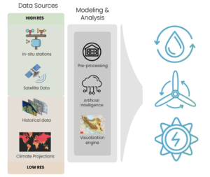
For the seamless integration of the most advanced AI and statistical downscaling techniques in the existing operational workflow.
2) Exploitation of the in-situ observation
To reach 4 km of spatial resolution at a national level while considering the climatic and morphological characteristics of the country.
📂 Resources: Click here or scroll to the bottom of this page to download maps, technical guides, Jupyter notebooks, and training materials supporting the Renewable Energy Atlas initiative.
Background
Identifying the gap
- More than 100 countries have responded to the survey.
- NMHSs were encouraged to consult with energy ministries and relevant stakeholders
- Only 20% of NMHSs currently have operational national renewable energy atlases.
- Many countries either lack national atlases or rely on outdated ones.
- Many countries only have atlases mainly for solar and wind energy. Very few countries have hydropower atlas.
Results available at: Profiles – Energymeteorology
Atlases are crucial
To support countries in achieving Paris Agreement goals and SDG7 targets in a changing climate
- Resource Assessment
- Infrastructure planning
- Policy Development
- Investment Attraction
- Long-term strategic energy planning
- Support Water-Energy-Food-Ecosystem (WEFE) nexus approach in resource management
- Integration into NDC 3.0
Objectives
IMPACT
Support countries in moving towards Renewable Energy Transition with the aim to cover all WMO Members requiring assistance by 2030.
OUTCOME
Enhancing the capacities of NMHSs through the co-development of climate services, enabling the production of national atlases in collaboration with energy ministries and other key national energy stakeholders.
OUTPUT
Developing a scalable approach/ instruction for producing high-resolution national renewable energy atlases (Wind, Solar, Hydropower) in WMO Members.
Characteristics
General Approach
- A bottom-to-top approach (NMHS/Sustainability)
- Leverage NMHS as authoritative source for national data
- Co-development approach
- Collaboration with pioneer international organizations
Technical Approach
- Scalable
- Baseline maps with personalization options
- Open access data with expandable layers
- Re-analysis, observational & climate projection data
Standard Output Package
- Standard produced maps & technical documents
- Open-source codes in Jupyter Notebook
- Recorded training modules
- Webinars and training courses
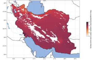
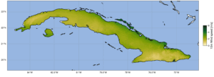
Visual Maps
Project Content and Materials
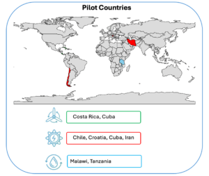
What you will get as a pilot country?
- Technical Guidelines
- Computer set up document: Anaconda Navigator download and environments installation.
- User manual: climate data acquisition and processing, sound AI-based downscaling method, interpretation and application of NRA’s outputs, capacity building for NMHSs.
- Recorded training sessions: technical support offered in the webinars.
- Open access data:
- World shapefile with the bounds of every country.
- DEM data: geopotential, orography and aspect at different resolutions.
- Hydrogeological data: river networks, catchments boundaries, lakes shapes at different resolutions.
- Open-source Codes:
- Jupyter Notebooks: data management in the NRAs creation and visualization for present and future climates.
- Github: you will find a dedicated folder for each renewable source, containing the notebooks related to the corresponding methodology.
- Files .yml: with the packaging needed to run the codes, to be added on Anaconda environment.